From Seabed to Shoreline: The Impact of Earthquake-Induced Coastal Uplift on Coastal Habitats in the Philippines
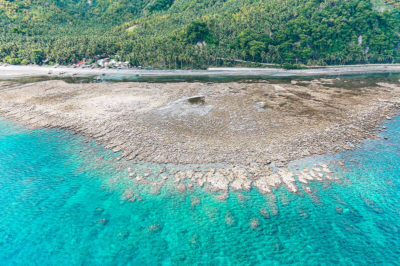
An aerial photo shows the coastal uplift following a magnitude 7.8 earthquake along the Pangyan Marine Sanctuary in Glan, Sarangani, Philippines (Photo Credit : AFP)
The Philippines is one of the most geologically active countries in the world, sitting squarely along the Pacific Ring of Fire, a region where the collision and subduction of tectonic plates make earthquakes a fact of life. Most people think of earthquakes in terms of crumbling buildings, collapsed infrastructure, or the threat of tsunamis. Far less discussed, but equally consequential for coastal communities, is what happens at the shoreline when the ground itself is permanently pushed upward.
This process, coastal uplift, occurs when an earthquake suddenly releases accumulated tectonic stress, causing portions of the seafloor and coastline to rise by anywhere from centimeters to several meters. The change happens in minutes. For habitats that have been submerged for centuries, there is no time to adapt.
The magnitude 7.8 earthquake that struck offshore Mindanao on June 8, 2026, brought this phenomenon into sharp focus. In parts of Sarangani and Davao Occidental, the seafloor rose by up to two meters, pushing the shoreline outward by as much as 200 meters and exposing coral reefs, seagrass beds, and intertidal communities to open air. Beaches that local families had known their entire lives became unrecognizable overnight.
Understanding Coastal Uplift
Coastal uplift occurs when tectonic forces cause a section of the Earth’s crust to rise relative to sea level. In subduction zones, stress accumulates as tectonic plates interact over time. When this stress is suddenly released during an earthquake, portions of the coastline may be elevated by several centimeters to several meters.
Philippine earthquake raises seabed by two meters (Photo Credit : Asean Today)
The Philippines sits along active plate boundaries involving the Philippine Sea Plate and the Eurasian Plate, making it highly susceptible to this process. Unlike gradual geological changes that occur over centuries, earthquake-induced uplift happens instantaneously, leaving ecosystems little time to adjust.
The June 2026 earthquake was triggered by movement along the Cotabato Trench, one of six active subduction trenches in the Philippines. PHIVOLCS confirmed that the rupture caused coseismic uplift along approximately 100 km of coastline in southern Mindanao, raising the seafloor by up to two meters in some locations. Satellite imagery from the Philippine Space Agency documented the before-and-after extent of the change, showing what had been a shallow marine habitat now sitting permanently above the waterline.
What makes coseismic uplift ecologically significant is its speed. Gradual sea-level changes, even those driven by climate, give organisms some time to adjust, migrate, or acclimate. An uplift of two meters in seconds gives them none.
Effects on Coral Reef Ecosystems
Coral reefs are among the most diverse and productive ecosystems on the planet and also among the least tolerant of sudden environmental change. Corals require continuous submersion in well-oxygenated seawater. Their survival depends on stable water temperature, light penetration, and humidity, conditions that are shattered the moment a reef is lifted above sea level.
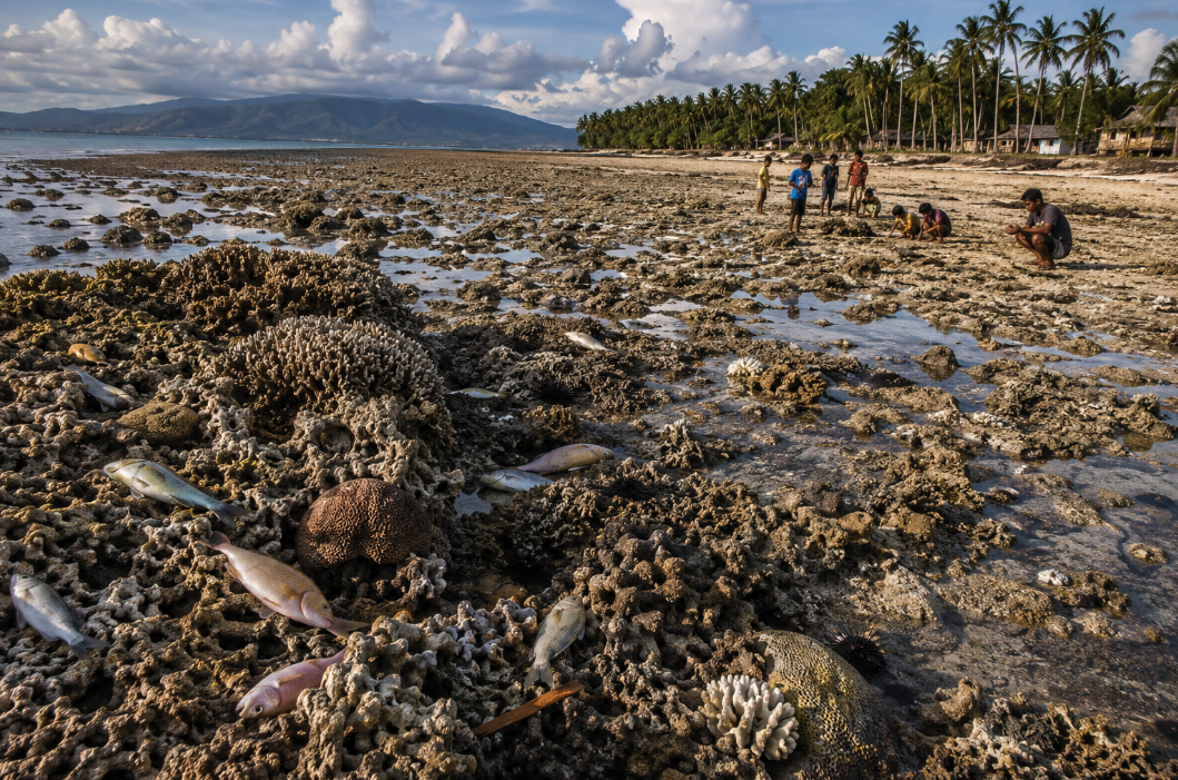
Exposed corals after coastal uplift following an earthquake along the Pangyan Marine Sanctuary in Glan, Sarangani, Philippines (Photo Credit : AFP)
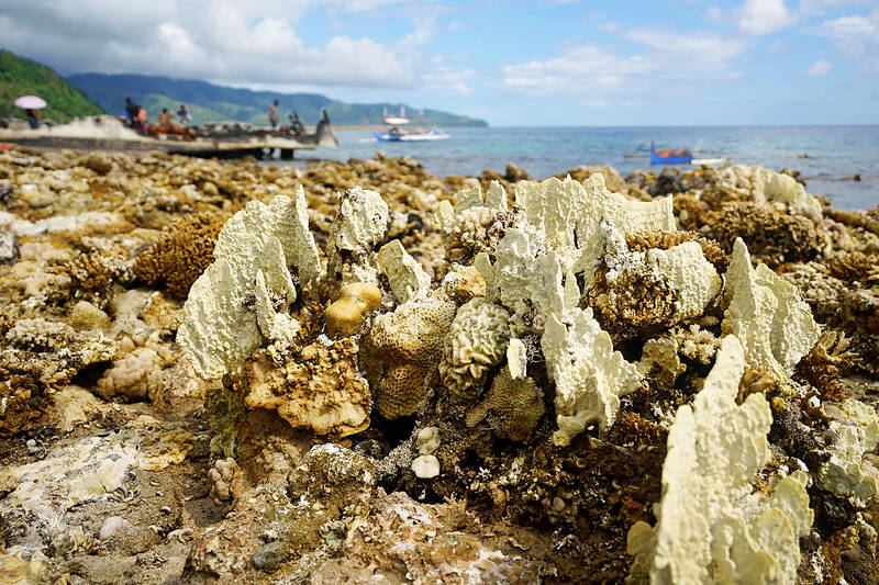
In Barangay Pangyan in Glan, Sarangani, and Barangay Burias in Jose Abad Santos, Davao Occidental, coastal uplift of two to 2.5 meters exposed extensive reef sections that had been underwater. Within days, DENR field teams documented visible die-off of coral colonies, reef fish, eels, clams, and other reef-dependent organisms. What had been a functioning marine sanctuary became a field of bleaching and decaying coral.
The Pangyan Marine Sanctuary, part of Sarangani Bay's protected area system, was among the habitats directly affected. The sanctuary is within the Coral Triangle, one of the most biodiverse marine regions on Earth. The ecological loss is not just local; it represents the destruction of habitat that supports larval dispersal, fish recruitment, and biodiversity at a regional scale.
Dead coral does not simply leave a space. The loss of three-dimensional reef structure reduces habitat complexity, which in turn drives declines in fish abundance and invertebrate diversity. Reefs also act as natural wave-energy dissipators — their degradation increases coastal vulnerability to erosion and storm surge in areas that are already geologically unstable.
Impacts on Seagrass Meadows
Seagrass meadows play a critical role in coastal ecosystems by stabilizing sediments, storing carbon, and providing nursery habitats for fish. However, they are highly sensitive to changes in water depth and tidal exposure.
Coastal uplift can leave seagrass beds partially or fully exposed, disrupting photosynthesis and increasing heat stress. In the aftermath of the Mindanao earthquake, changes in coastal elevation altered the conditions required for seagrass survival in some areas.
The decline of seagrass habitats can have cascading effects on fish populations and fisheries, as many species rely on these ecosystems during early life stages. This can ultimately impact food security and local livelihoods.
Changes in Mangrove Ecosystems
Mangroves are built for the intertidal zone, that shifting boundary where land and sea overlap. Their survival depends on a predictable rhythm of tidal flooding: enough inundation to maintain soil moisture and exclude salt buildup, but not so much that the trees are permanently submerged.
Coastal uplift disrupts this rhythm. When land rises, areas that were previously flooded twice daily may only be reached during the highest tides, or not at all. Soil salinity and nutrient dynamics shift. The anaerobic conditions many mangrove species rely on for root function may change as drainage patterns reorganize around the new elevation.
In the short term, mangroves in uplifted areas may survive; they are resilient trees. But over months and years, species adapted to regular inundation will likely face mortality as conditions drift outside their physiological tolerance. At the same time, newly exposed intertidal surfaces may offer colonization opportunities for pioneer mangrove species, particularly where suitable sediment and propagule supply are available.
In the Mindanao earthquake zone, researchers expect gradual ecological reorganization rather than immediate mass die-off in mangrove areas. The pace of change will depend on how dramatically individual sites were uplifted and whether residual tidal connectivity remains. Monitoring over the coming years will be critical to understanding whether local mangrove cover contracts, shifts, or partly recovers in a new configuration.
Consequences for Intertidal Communities
Intertidal ecosystems are particularly sensitive to changes in elevation because organisms are adapted to precise tidal zones. Barnacles, mussels, oysters, crabs, and algae all occupy specific vertical ranges along the shoreline.
When uplift occurs, these zones are displaced. Organisms that become exposed too far above the waterline often experience desiccation and die-off, while newly exposed surfaces are gradually colonized by different species.
These shifts can disrupt food webs and affect species that depend on intertidal resources, including fish and shorebirds.
The 2026 Mindanao Earthquake: Coastal Uplift in Real Time
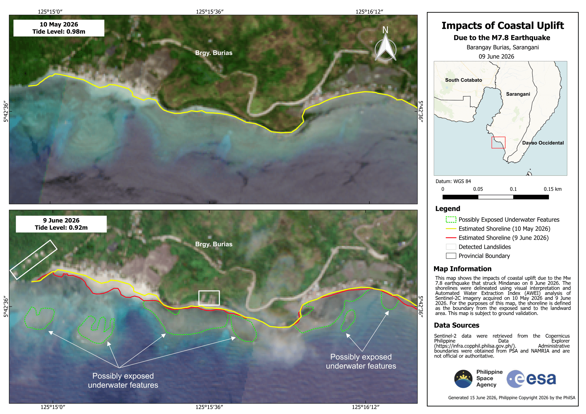
The impact of the coastal uplift in Barangay Burias, Sarangani, following the powerful June 8, 2026 earthquake (Photo Credit : Philippine Space Agency)
On the morning of June 8, 2026, a magnitude 7.8 earthquake struck approximately 32 kilometers west of Maasim, Sarangani, at a depth of around 33 kilometers. The earthquake was caused by thrust faulting along the Cotabato Trench, one of the most seismically active subduction zones in the Philippines, and was felt across a wide swath of Mindanao.
In Glan, Sarangani, and Jose Abad Santos, Davao Occidental, residents noticed something unusual in the hours that followed: the sea had not come back. Tide levels remained abnormally low. What residents were observing was the aftermath of coseismic uplift. By June 11, aerial surveys by PHIVOLCS and the Mines and Geosciences Bureau confirmed that the coastline had risen by approximately two meters across a 100-kilometer stretch of southern Mindanao, pushing the shoreline up to 200 meters seaward.
The ecological consequences were immediate and visible. Coral reefs in the Pangyan Marine Sanctuary were exposed to direct sunlight for the first time. Seagrass beds emerged from the water. Dead fish, eels, and shellfish washed ashore as marine life trapped in rapidly shallowing and evaporating tide pools perished. DENR Soccsksargen issued safety advisories warning residents to avoid touching stranded marine life due to a biological hazard from decomposition.
For local fisherfolk, the transformation was both disorienting and alarming. The coastal geography that defined their livelihoods, the reef edges, the seagrass flats, and the channels navigated daily by small boats, had permanently changed. Shifting tide levels and newly exposed seabed made navigation difficult. Fishing grounds that had been productive for generations were now exposed land.
A multidisciplinary team from DENR, PHIVOLCS, and the Mines and Geosciences Bureau launched a comprehensive coastal assessment beginning June 16. The Philippine Space Agency contributed satellite-derived maps comparing pre- and post-earthquake vegetation and shoreline positions. These geospatial tools were critical for quantifying the spatial extent of habitat loss across the affected coastline, an area too large for a rapid ground-level survey alone.
PHIVOLCS has been clear that the uplift is permanent. The new shoreline will not return to its previous position through natural tectonic rebound. Over time, wave erosion, sediment deposition, and biological colonization will gradually soften the landscape — but the fundamental elevation change is fixed. The communities of Glan and Jose Abad Santos are, in a geological sense, living in a different place than they were on June 7.
Future Implications for Coastal Conservation
The 2026 Mindanao event raises practical questions for coastal management that extend well beyond disaster response. Marine protected areas, like the Pangyan Marine Sanctuary, are designated based on the distribution and condition of habitats at a particular point in time. A coseismic event that shifts those habitats by 200 meters horizontally and two meters vertically does not just damage the ecosystem; it challenges the spatial logic of the protection itself.
Similarly, coastal setback regulations, infrastructure planning, and aquaculture zone designations are all built on assumptions about stable shoreline positions. The Philippines' location along multiple active subduction trenches means that coseismic uplift is not a rare outlier; it is a recurring feature of the geological environment. The 2013 Bohol earthquake produced a comparable, if smaller-scale, coastal uplift in Loon and Maribojoc. The 2025 Cebu earthquake caused one meter of uplift in Barangay Nailon, Bogo City.
Integrating geological hazard mapping, particularly the spatial extent and probability of coseismic coastal deformation, into marine spatial planning is a logical next step. GIS-based monitoring using satellite imagery, as demonstrated by the Philippine Space Agency's response to the 2026 event, offers a scalable approach to detecting and quantifying coastal change in near real time following seismic events.
Lessons from the Seafloor
Earthquakes are usually framed as events that happen to buildings and roads. But for coastal ecosystems, a major seismic event can be equally, and in some ways more permanently, destructive. Coral reefs, seagrass meadows, mangrove forests, and intertidal communities cannot be rebuilt the way infrastructure can. Recovery, where it happens at all, is measured in decades.
The 2026 Mindanao earthquake exposed more than the seafloor. It exposed the fragility of marine habitats when confronted with geological forces that operate on timescales and magnitudes beyond any ecological adaptation. It also exposed a gap in how we think about coastal protection: when we plan for a marine sanctuary or a fisheries management zone, we rarely account for the possibility that the seafloor beneath it might rise two meters overnight.
For coastal communities in southern Mindanao, fisherfolk, resort operators, and local government units, the immediate priority is adaptation to a coastline that has fundamentally changed. For scientists and planners, the event is a prompt to think more seriously about the intersection of tectonics, ecology, and coastal governance in one of the world's most geologically active archipelagos.
The sea did not disappear. The land came up to meet it, and left behind a transformed coastline that will take years to fully understand, and far longer to recover.