Food Security in a Changing Coast: Field Insights from Mangrove Rehabilitation Assessment in Betahwalang Village, Indonesia
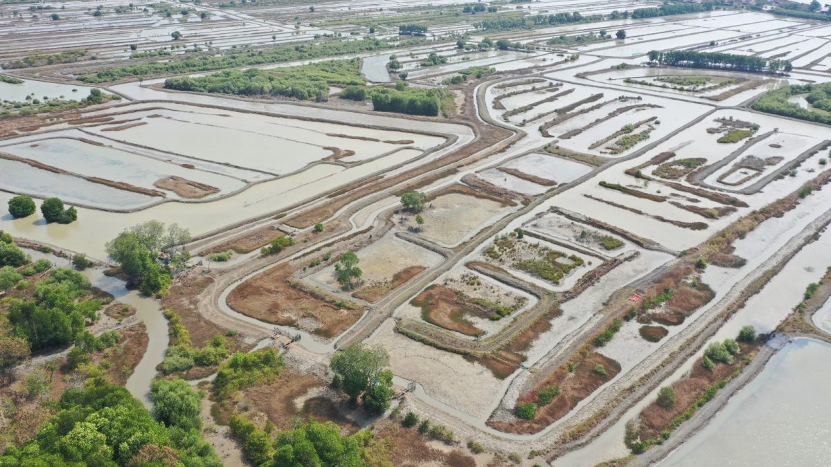
Photo Credit : GIS Coastal Indonesia
Along the northern coast of Java, the landscape tells a quiet story of change. What once functioned as a continuous belt of mangroves has gradually transformed into a mosaic of aquaculture ponds. Betahwalang Village, located in Bonang District, Demak Regency, is one of many coastal villages shaped by this long process. Today, it stands at the intersection of food security, ecosystem degradation, and climate pressure, making it a critical site for understanding the feasibility of mangrove rehabilitation in aquaculture-dominated areas.
In early fieldwork for a mangrove rehabilitation feasibility study, GIS Coastal conducted integrated environmental and socio-economic assessments in Betahwalang. The objective was not simply to evaluate whether mangroves could be replanted, but to understand how ecological conditions, land use history, and local livelihoods interact, and what that interaction means for coastal resilience and food security.
From Mangroves to Pond: A Historical Shift
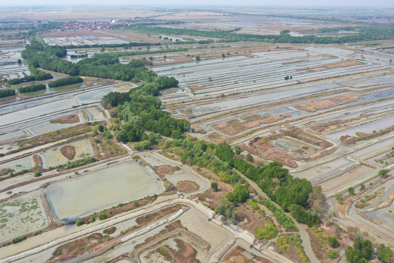
Photo Credit : GIS Coastal Indonesia
Based on satellite imagery, historical references, and local resources, Betahwalang’s coast has long been dominated by aquaculture ponds. Older residents recall that fishponds were already widespread by the 1970s. Mangroves appear to have survived only in small patches, mainly along tidal channels and less-managed coastal edges, rather than forming a continuous mangrove belt.
The rapid expansion of ponds began to accelerate in the late 1980s and 1990s, following broader trends along Java’s north coast. Aquaculture promised economic opportunity and food production, particularly for milkfish and shrimp. Mangroves were cleared, embankments constructed, and tidal flows modified to maximize pond area. Over time, these changes reshaped the coastal system in ways that were not fully anticipated.
What initially appeared as development later revealed its vulnerabilities. As mangroves disappeared, the coast became increasingly exposed. Tidal flooding became more frequent, embankments required constant maintenance, and pond productivity became less predictable. These changes have direct implications for food security, both in terms of seafood availability and household income.
Why Betahwalang Matters for Food Security
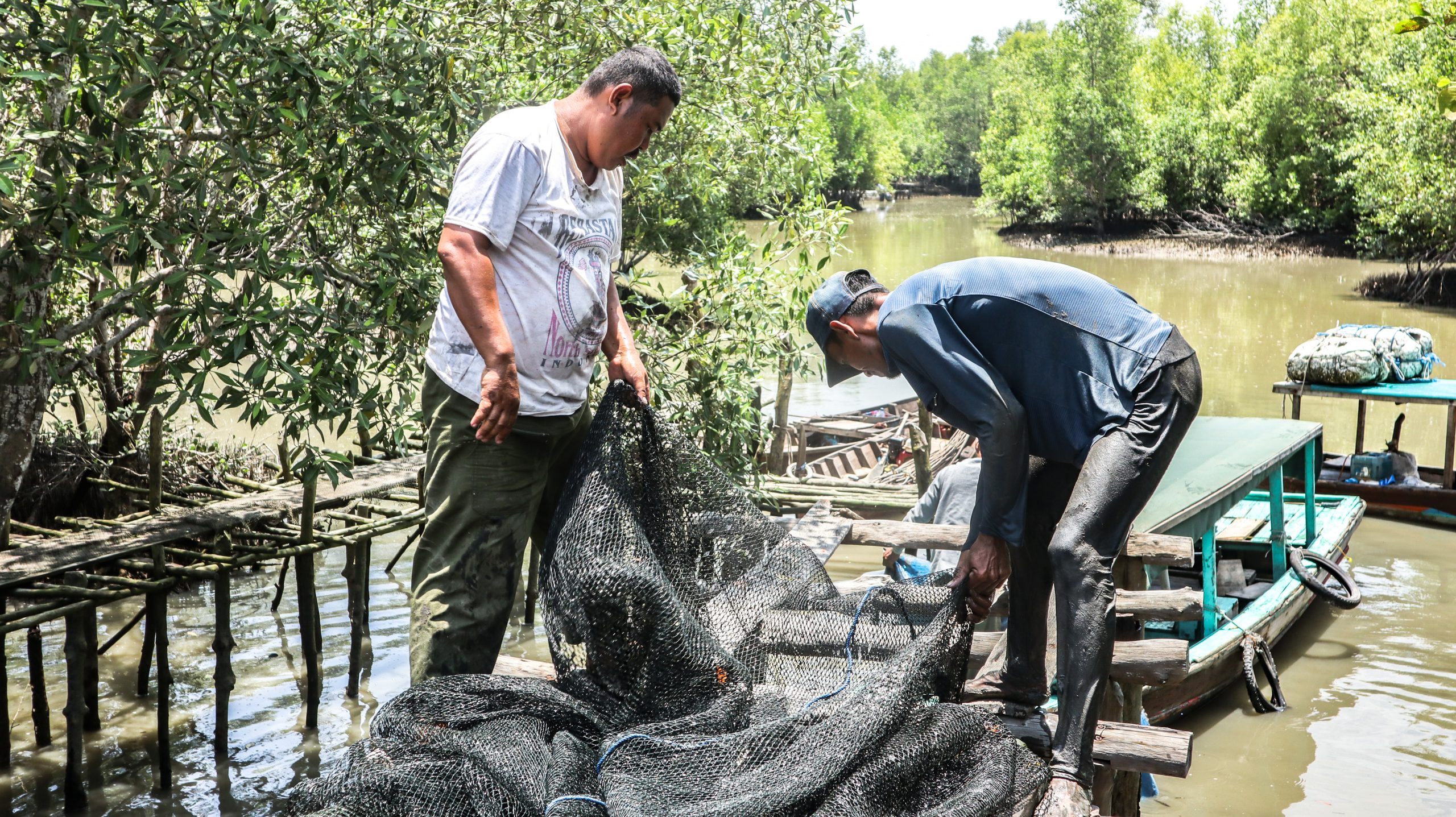
Photo Credit : Yagasu
Food security in coastal villages like Betahwalang cannot be separated from ecosystem condition. Fish and other aquatic resources remain a primary source of protein, while income from aquaculture and capture fisheries supports access to other foods. When environmental conditions deteriorate, food security becomes unstable, even if aquaculture infrastructure remains in place.
In Betahwalang, many households depend on a combination of pond-based aquaculture and nearshore fishing. This dual reliance makes them particularly sensitive to ecosystem degradation. Poor water quality, unstable sediments, and fewer fish growing up in these waters now affect both daily food supply and household income.
Climate change adds another layer of pressure. Rising sea levels, stronger tidal inundation, and changing rainfall patterns affect pond salinity, infrastructure stability, and fishing schedules. These changes are not future projections; they are already part of daily decision-making for coastal households.
Fieldwork Approach: Integrating Ecology and Society
The feasibility study combined field sampling, spatial analysis, and socio-economic exploration. Environmental assessments focused on water quality and sediment characteristics across selected ponds and adjacent degraded mangrove areas. Salinity, pH, dissolved oxygen, and sediment texture were measured to understand both current pond conditions and the suitability of sites for mangrove rehabilitation.
Sampling locations were selected based on spatial analysis of historical land use change, proximity to tidal channels, and remaining mangrove patches. This GIS-based approach allowed the team to link field observations with broader coastal processes, rather than treating each pond as an isolated unit.
At the same time, socio-economic data were collected through interviews and informal discussions with pond owners, fishers, processors, and village elders. These conversations focused on livelihood strategies, perceptions of environmental change, and local experiences with flooding, erosion, and declining productivity. Rather than extracting data, the process emphasized understanding how people interpret and respond to coastal change.
What the Field Data Revealed
Environmental sampling showed clear signs of long-term alteration. Many ponds exhibited high salinity and low dissolved oxygen levels, conditions that stress aquaculture species and reduce overall productivity. Sediment profiles in former mangrove areas were often compacted and lacked organic layers, indicating reduced capacity to support natural mangrove regeneration without intervention.
However, the data also revealed opportunities. In areas where tidal exchange remained partially intact and sediment supply was sufficient, pioneer mangrove species were present. These patches demonstrate that ecological recovery is possible when hydrological conditions allow.
From a food security perspective, these findings matter. Healthy mangrove systems support fisheries that extend beyond pond boundaries. Their decline reduces the availability of wild fish and crustaceans that supplement household diets and income, especially during periods when pond yields are low.
Socio-Economic Realities on the Ground
Conversations with local residents consistently highlighted a sense of trade-off. Ponds expansion brought income and employment, but it also increased exposure to coastal hazards. Many households described a growing uncertainty in both fishing and aquaculture, particularly during extreme weather events or prolonged dry seasons.
Older residents recalled a time when mangroves reduced wave energy and flooding impacts. Younger residents, while more focused on immediate economic needs, increasingly recognized the costs of environmental degradation. This intergenerational perspective is important, as it shapes local support for rehabilitation initiatives.
Food security concerns emerged not only as an issue of production, but also of stability. When pond yields fail or fishing days are lost due to rough conditions, households reduce food diversity and rely on cheaper, less nutritious options. Women, who often manage household food and engage in fish processing, are especially affected by fluctuations in raw material supply.
Mangrove Rehabilitation as an Integration Challenge
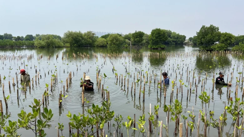
Photo Credit : World Bank
Field findings in Betahwalang show that mangrove rehabilitation cannot be approached as a blanket restoration effort. Aquaculture ponds are not a recent feature of this landscape. They are established, owned, and actively managed, and many households depend on them as their main source of income. Expecting large areas of existing ponds to be fully restored to mangroves is neither practical nor socially acceptable.
What the feasibility study highlights instead is the need for selective and integrated approaches. Some areas remain technically suitable for mangrove recovery, especially along tidal channels, pond boundaries, and low-productivity zones where tidal flow can still be restored and sediments are actively moving. In contrast, heavily modified ponds that are hydrologically isolated would require major intervention and may be better managed through alternative strategies rather than full restoration.
From the field perspective, the question is not mangroves versus aquaculture, but how the two can function together within the same coastal system. Integrating mangroves into aquaculture landscapes can improve long-term productivity and reduce risk. Mangroves help stabilize sediments, buffer waves, improve water quality, and support fish and crab populations that move between ponds and nearshore waters. These benefits directly support both food security and livelihood stability.
In Betahwalang, this integration can take many forms. Mangroves can be re-established along pond canals and coastal edges to protect embankments and reduce maintenance costs. Less productive or frequently flooded pond sections can be repurposed as mangrove buffers without eliminating core production areas. Such arrangements reflect existing practices observed in the field, where small mangrove patches already survive and provide localized benefits.
Lessons for Coastal Planning and Practice
The experience in Betahwalang underscores the importance of combining scientific assessment with local knowledge. Environmental data alone cannot capture the full picture of food security and resilience. Likewise, social insights must be grounded in an understanding of coastal processes and spatial dynamics.
For practitioners, this means designing rehabilitation projects that are realistic, participatory, and adaptive. For policymakers, it highlights the need to view mangrove rehabilitation not as an environmental luxury, but as a foundational investment in coastal food systems.
Betahwalang’s story is not unique. Across many coastal regions, similar patterns of ecosystem conversion and climate pressure are unfolding. What makes this case valuable is the opportunity to learn how integrated assessment can inform more sustainable coastal futures.
Looking Forward
Mangrove rehabilitation in aquaculture landscapes is not about returning to the past. It is about redefining how coastal systems function under current and future conditions. In Betahwalang, the feasibility study shows that pathways toward greater food security and resilience do exist, but they require careful planning, long-term commitment, and collaboration between communities, scientists, and practitioners.
As climate change continues to reshape coastal environments, the question is no longer whether restoration is needed, but how it can be done in ways that support both ecosystems and the people who depend on them. Betahwalang offers a grounded example of how that question can begin to be answered.