When the Sea Keeps Advancing: Lessons from a Coastal District in Demak on the Future of Indonesia’s Shorelines
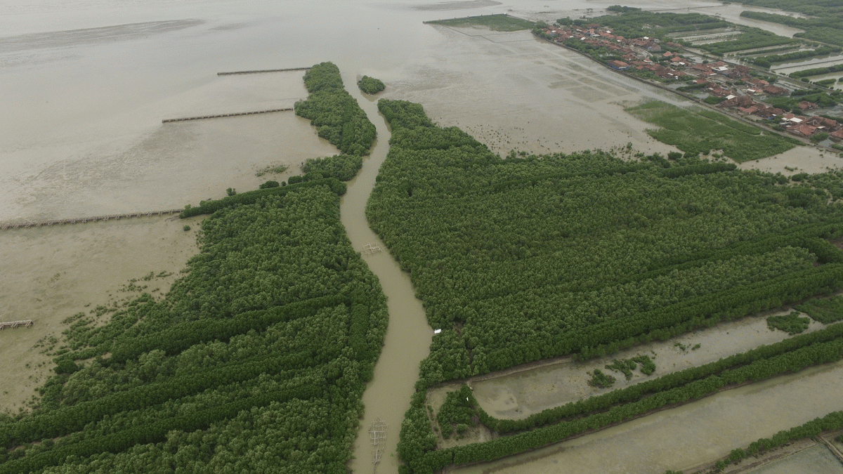
Photo Credit : Wetlands International
In a coastal district of Demak Regency, Central Java, the sea no longer arrives only with the seasons. It comes more often, it reaches farther inland, and in some places, it does not fully retreat.
Fishponds that once sustained households are flooded for longer periods. Village roads turn brackish. Patches of mangroves stand scattered, like the last remaining line of natural defence along a retreating shore.
For GIS Coastal, these are not isolated environmental symptoms. They are clear signals that the way we plan coastal development must change, becoming more data-driven, more ecologically grounded, and far more attentive to the people living at the front line of climate change.
This article reflects professional insights drawn from a field-based feasibility study in one coastal district of Demak. It does not disclose technical designs or project-specific decisions but rather illustrates how early-stage studies can shape more resilient and responsible coastal futures.
Reading the Coast from the Ground Up
Rather than arriving with ready-made designs, the GIS Coastal team began with a simple question: What is truly happening here?
The first days in the field were spent walking along pond embankments, speaking with fishers and farmers, observing remaining vegetation, and noting how tidal flooding reshaped daily routines.
Visual surveys were paired with geospatial analysis to track shoreline change over time. Water-quality sampling provided clues as to why productivity in some ponds had declined. Community discussions revealed stories rarely captured on maps: the rising cost of repairing dikes, shifting harvest seasons, and parents worrying about whether their children would still be able to live from coastal livelihoods in the decades ahead.
It quickly became clear that coastal challenges in Demak are not merely physical processes. They are economic pressures, social uncertainties, and questions of long-term habitability.
Mangroves That Still Hold Promise
Amid these stresses, Demak’s shoreline still retains something precious fragments of mangrove ecosystems that continue to persist.
Field inventories recorded multiple mangrove species, including Rhizophora and Avicennia, along with fauna that depend on them: mud crabs, juvenile fish, shrimp, water birds, and molluscs.
For GIS Coastal, this matters deeply. It means rehabilitation does not start from zero. Ecological foundations remain if planning is careful, strategic, and rooted in science.
Mangroves are not simply coastal trees. They are living infrastructure: wave buffers, sediment traps, carbon sinks, and nurseries for fisheries. In landscapes under intense pressure like Demak, every surviving stand is a strategic asset.
Seeking Common Ground Between Ecology and Livelihoods
One of the most sensitive questions in the district concerns the relationship between fishponds and mangroves. Ponds support local incomes. Mangroves protect shorelines. Too often, these two are framed as opposites.
In Demak, GIS Coastal explored pathways that attempt to reconcile them, most notably through silvofishery systems, which integrate mangrove vegetation into aquaculture landscapes.
This approach was not presented as a quick fix. It was assessed as a long-term option capable of improving environmental quality while stabilizing household economies. With careful design, mangroves can return within pond systems. Water conditions may recover. Productivity could improve. Natural coastal protection may strengthen. For GIS Coastal, this is the essence of sustainable coastal development: not choosing between people and nature but designing systems in which both can endure together.
Behind the Numbers: Perceptions and Power Dynamics
Field data alone is never sufficient. Conversations with residents revealed a wide range of attitudes, hope for shoreline recovery, concern over changing management practices, and memories of past projects that never delivered lasting benefits.
GIS Coastal therefore mapped not only physical conditions, but also stakeholder perceptions: fishers, pond operators, village leaders, government agencies, and local institutions. Who holds influence? Who must be engaged early? Where might resistance arises? These questions became integral to the study. Without social insight, even the most sophisticated engineering solutions remain fragile.
Lessons That Reshape Planning
Several powerful lessons emerged from the Demak experience. Coastal planning must begin with ecological realities, not desk-based assumptions. Structural measures alone cannot succeed if ecosystems collapse. Rehabilitation will falter if communities feel excluded. And strong feasibility studies are those that confront risks and limitations honestly not merely highlight opportunities.
For GIS Coastal, Demak offers a preview of what many Indonesian coastlines may soon face. Abrasion, tidal flooding, mangrove loss, aquaculture vulnerability—these are no longer isolated cases. They are becoming a pattern.
Restoring the Meaning of Feasibility Studies
In development practice, feasibility studies are sometimes treated as procedural steps before construction begins. The work in Demak suggests the opposite. When conducted rigorously, early-stage studies can protect investments, prevent further environmental degradation, and open pathways toward fairer, more climate-resilient outcomes for coastal communities.
By reading the coast as an integrated ecological, social, and economic system, GIS Coastal advocates that every shoreline project should start with understanding before intervention. Because at the edge of climate change, planning mistakes are not just financial. They shape lives.
Demak as a Mirror of Coastal Futures
A single coastal district in Demak may appear small on a national map. Yet its lessons extend far beyond its boundaries.
They speak to the choices facing Indonesia’s shores today: whether to continue reacting to erosion and flooding, or to design proactively guided by science, community realities, and long-term sustainability.
For GIS Coastal, this is the direction forward: linking field data to policy, integrating ecosystem restoration with local livelihoods, and ensuring that coastal development does not merely survive environmental change, but recovers and thrives alongside it.
-Rika Novida